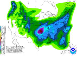
Our Next Cold Front Means Business!

For some strange reason, our local NOAA people are not taking this next front very seriously. Latest computer models continue to show a major dip in the jet stream and some very cold air (for this time of the year) pouring southward on Friday night and Saturday with brisk winds and moisture. This is essentially an "arctic front" in late March. In fact, one of the models shows snowfall as far south as Waco on Saturday. Meanwhile, our local NOAA forecasters are not even mentioning the possibility of freezing temperatures on Sunday or Monday morning for the San Antonio area. If the winds do not stop blowing on Saturday night and a few clouds linger, I can understand why we might stay in the mid 30's, but if it clears on Sunday and the winds go calm, I see no reason we won't get into the lower 30's or upper 20's in northern Bexar County.
Rainfall will stay mostly to our north and northeast, but we should still see 1/4 to 1/2 inch amounts by Saturday night. Another strong front will come in later next week, with another chance of rain and some more cold air. At this time, I don't think we will see a freeze, but we could see some more "30 something" lows.


Those NOAA people are not reading your blog, evidently. :)
ReplyDelete