Latest from NOAA

Most of south central Texas has enjoyed a beautiful day after the large thunderstorm cluster brought more flooding overnight. Late this afternoon, some strong thunderstorms are already forming over the far western hill country near Mason. These may stick together and bring an evening thunderstorm threat to areas generally west of Austin say across mainly Llano and Burnet counties. These storms will have to overcome some capping in the atmosphere to make it farther east however...so we will keep the chances of this happening at about 30-40%. Strong gusty winds in excess of 60 mph and large hail would be the primary threat. These may last well into the evening hours if they can hold together.
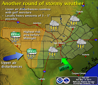
Also of concern is yet another upper level disturbance over southern NM which will be moving across west Texas later tonight and then likely triggering additional storms west of our area late tonight. Much like last night...these storms may organize into a large cluster of storms and move over south central Texas primarily after midnight. The main threat if this scenario plays out, would be locally heavy rains in the 3-5 inch range. There is a small severe threat later tonight over the SW near the Rio Grande as large storms fire over the Mexican mountains and move east of the Rio Grande.
Unfortunately there is still a lot of uncertainty about the scenarios. But everybody needs to be on the lookout. Many areas cant handle any additional rainfall. Many rivers, creeks, and rivers are already in Flood stage. A Flash Flood Watch may have to be considered later tonight.
I have attached the latest graphic. Please keep watch this afternoon and tonight as the system develops. Log onto our website for the latest watches and warnings. www.srh.noaa.gov/ewx
Paul Yura
National Weather Service Austin-San Antonio TX


Comments
Post a Comment