2 Fronts, snow, sleet and freezing rain!
 OK...here we go!
 I've been reviewing the latest forecasts, modeling data and snow cover for the United States and I'm convinced we will see snow, sleet and freezing rain in San Antonio, starting on Wednesday and possibly going through Friday.
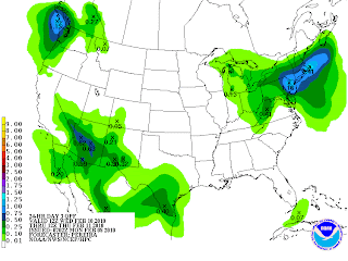
With 62% of the country now under snow cover and an arctic front making it's way southward tonight, it would not surprise me to see us stay at or below freezing from Tuesday night through Thursday or Friday. Because most areas to our north are under snow right now, this will preserve the cold air moving into South Texas tonight, making the air colder than current forecasts and models are indicating. The snow factor will also keep the cold air depth deeper, allowing a better chance for snow, starting on Tuesday night and Wednesday. The precipitation chart above shows forecast rainfall amounts on Wednesday. If this pans out in the form of snow, we could see 2-3 inches of the white stuff. Another upper level low moves in on Thursday. At this time, forecasts are for the high pressure to move to our east just enough to keep the precipitation in the form of sleet or freezing rain. If the high pressure does not move out as anticipated, we could see half a foot of snow on Thursday, based on precipitation forecasts. Actually, this scenario would be better for traffic and potential downed power lines if the precipitation falls as rain.
Here's how I see things progressing:
This afternoon, front #1 will move through, switching our winds into the north and giving us a chance for a small thunderstorm or two. Later tonight, the arctic front will move in, dropping temps into the lower 30's with high winds and a low wind chill on Tuesday. At this time, we may see enough sun on Tuesday to take us into the 40's for a high. Later on Tuesday, clouds will thicken as moisture starts moving over the high pressure from the Pacific. That's when things start getting interesting. A small upper level low will move in on Wednesday, giving us a good chance for snow on Wednesday morning and afternoon. Then, a stronger system moves in on Thursday and Friday. That's the one that could deliver either heavier snow or ice. My LCFS rating for the arctic front is 878. For an explanation on this system, please go to www.myweatherpage.com
Front #1 came through Helotes around 2:45 this afternoon. We got .13 inches of rainfall this morning and when the storm came through with the front.


Should be a fun few days. Thanks for all the info Mark.
ReplyDelete