Latest from NOAA

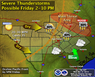
Here is the latest from NOAA on our storm chances for Friday...
For those northern areas of south central Texas...mainly north of Highway 71....the threat time will be from 2-10pm on Friday. Some storms may fire before the front pushes through. Other areas of south central Texas will likely see a "cap" on the atmosphere which will limit the thunderstorm potential...keeping rain chances fairly Isolated. Any storm that would break this "cap" would likely go severe...coverage would remain isolated however. It is spring time...so be on the lookout.
We will continue to watch the models and keep you updated as best we can. Visit us atwww.srh.noaa.gov/ewx for the latest forecast and graphics.
Paul Yura
National Weather Service Austin-San Antonio TX


Comments
Post a Comment